Cripple Creek Restoration Project
With almost six years of work and three years of construction projects, the historic Cripple Creek channel is finally seeing natural water flow after 85 years! IALT has actively worked with numerous partners including:
ADOT&PF, USF&WS, ADF&G, DOWL HKM Engineering, Drennon Construction, Great Northwest Inc., Fairbanks Soil & Water Conservation District, the University of Alaska Fairbanks, the Army Corps of Engineers, and Herrera Environmental Consultants
to successfully complete this project. Stop by our Chinook Conservation Park property to walk our trail along the creek channel, and stay tuned for more exciting developments with this property; we have more in store!

Two mile loop walking trail

The year-round walking/snowshoe trail loop, starting by the Justa Store.
History of the Project
Fairbanks – Alaska’s “Golden Heart City” – experienced significant ecological disruptions due to gold mining activity throughout the region in the early twentieth century. One such disruption was the reroute of Cripple Creek in 1935. Cripple Creek’s natural channel was bypassed to an artificial ditch or drain to convey excessive wastewater from hydraulic mining. Although hydraulic mining activity ceased years ago, the drain persists today. As a result, the natural channel habitat of Cripple Creek was abandoned for about eighty years, and the straight, channelized drain offered poor Chinook Salmon rearing habitat.
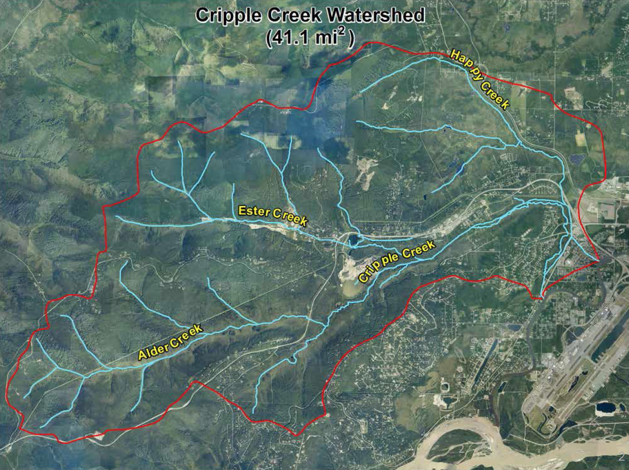
Alder creek, Ester creek and Happy creek all flow into Cripple Creek, which flows into the Chena River.
In the 1930s, the Chena Pump House was constructed to pump water over Chena Ridge for hydraulic mining efforts near Gold Hill. To expedite the return of hydraulic runoff (water and sediment) to the Chena River, engineers considered two alternatives: excavate a tunnel almost two miles long beneath Chena Ridge, or construct a drainage ditch almost six miles long around the northern toe of Chena Ridge. In the end, Cripple Creek Drain or “the ditch” was completed in 1935, diverting flow from the lower reaches of Cripple Creek.
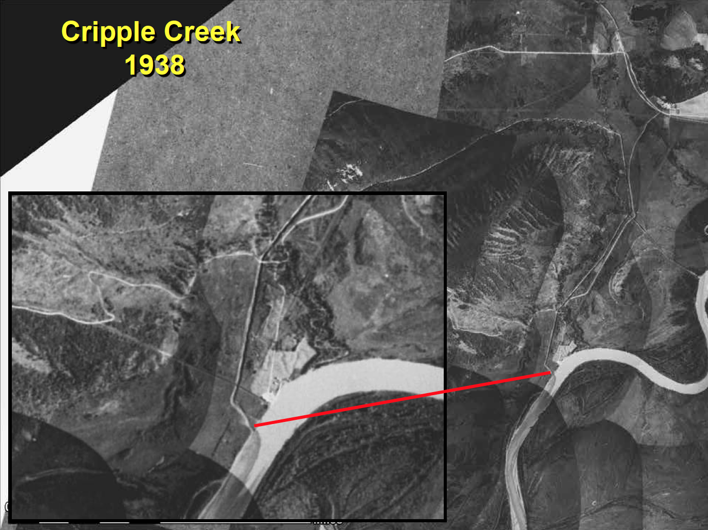
Effluent from Cripple Creek Drain is clearly visible just downstream from The Pump House. Courtesy Bob Henszey, USF&WS.
While the drain or ditch was an effective solution for the products of placer mining, the abandonment of Cripple Creek resulted in a tremendous loss of wildlife habitat. The lower reaches were effectively channelized down the ditch, which diminished habitat complexity, especially important eddy and pool structures along with important organic debris. Some hardy species, such as grayling, sculpin and blackfish, were able to survive in the drain. However, an important rearing area for chum and chinook salmon was lost.
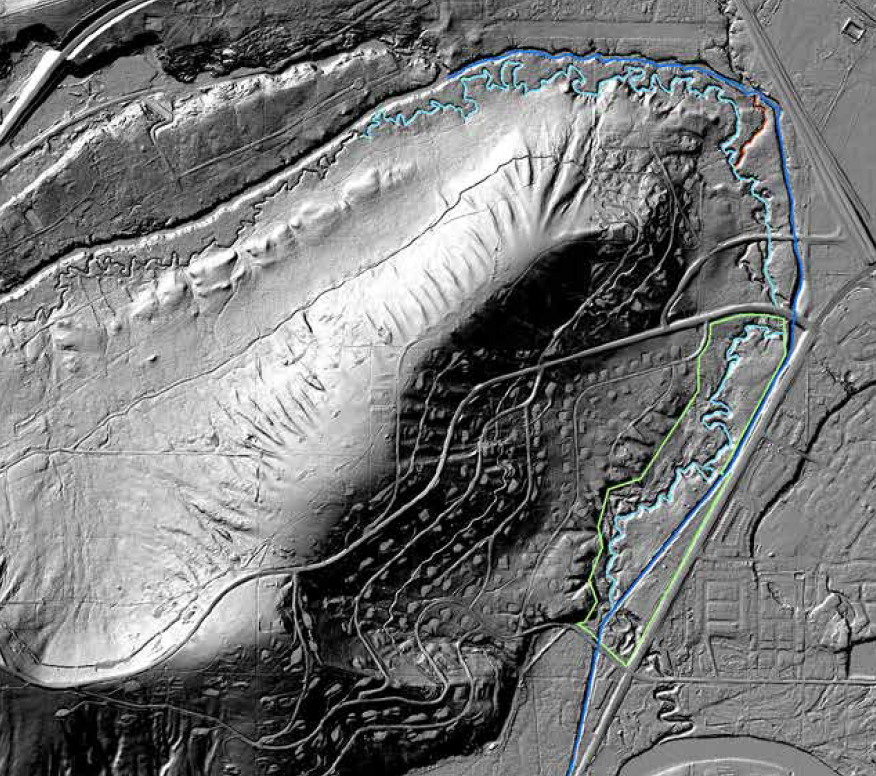
LIDAR image of Cripple Creek shows the difference between the historic channel and the Drain. Courtesy Bob Henszey, USF&WS.
For many years, this remained the status quo. In 1996, a new intersection at Chena Ridge Road and Chena Pump Road required rerouting lower Chena Ridge Road. The new ditch culvert can been seen in 1996 aerial imagery.

The ditch culvert at Chena Ridge Road during construction. Courtesy Bob Henszey, USF&WS
However, no culvert was included to connect the channel of Cripple Creek through Chena Ridge Road. Over time, limited flow accumulated in the channel as impounded water on the north side of Chena Ridge Road. This unanticipated impoundment formed a continuous stagnant pond reaching well above Chena Spur Road to the north.

Impounded water on the north side of Chena Ridge Road, and the ditch during low flow. Courtesy Bob Henszey, USF&WS
IALT, in partnership with the USF&WS, commissioned feasibility studies determining requirements for returning flow to the historic Cripple Creek channel. Several options were considered but each was just out of reach logistically and financially. In the fall of 2014, IALT learned that Alaska Department of Transportation and Public Facilities planned to replace the aging ditch culvert at the intersection of Chena Ridge and Chena Pump roads in the near future. The ditch culvert replacement project provides a great opportunity to place an additional new fish passage culvert in the abandoned Cripple Creek channel, restoring some flow to lower Cripple Creek.

Intersection at Chena Ridge Road and Chena Pump Road showing impoundment and existing ditch. Courtesy Bob Henszey, USF&WS.
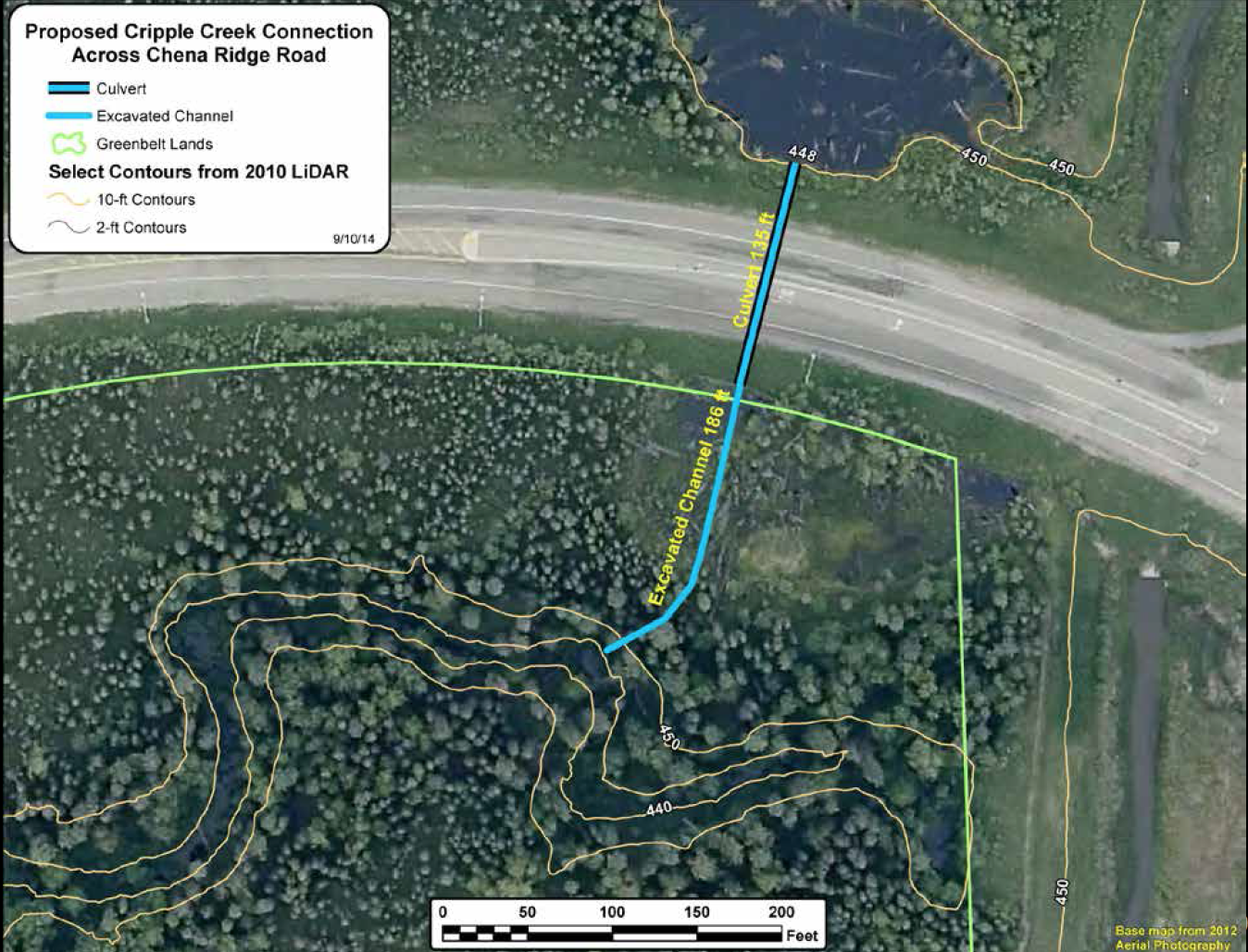
Proposed reconnection culvert and excavation. Courtesy Bob Henszey, USF&WS.
The Interior Alaska Land Trust, in partnership with the U.S. Fish & Wildlife Service, studied the restoration feasibility of Cripple Creek in the lower Chena River watershed for almost a decade, including funding several extensive studies by Herrera Environmental Consultants and DOWL HKM Engineering. Careful analysis by U.S. Fish & Wildlife Service and Alaska Department Fish & Game habitat biologists determined that the restoration of Cripple Creek and improvements to its fish passages will improve overall juvenile Chinook Salmon rearing habitat within the Chena River Watershed. After years of seemingly insurmountable obstacles, restoring Cripple Creek fortuitously became possible and began in the spring of 2017 with four goals:
- Reconnect Happy Creek to Cripple Creek channel
- Redirect ditch flow back into Cripple Creek near Happy Creek
- Replace Chena Spur Road culverts
- Modify the culvert at Old Chena Ridge Road for fish passage guidelines
Project Specifics
To fully restore the creek and the watershed’s habitat, two fish passage constrained culverts at road crossings (Old Chena Ridge Road & Chena Ridge Road) needed to be replaced, and, the creek’s flow redirected from the upper reaches of the drain back into the historic channel. (See below map). The first culvert at Old Chena Ridge Road was retrofitted in the summer of 2017 by reconfiguring the channel and creating a new stilling pond with a series of rock weirs on the downstream end of the culvert. This work was funded by a $60,000 grant from the USFWS Yukon River Salmon Research and Management Fund.
The second culvert project at Chena Ridge Road was facilitated by the Alaska Department of Transportation & Public Facilities (AKDOT&PF) in the summer of 2018 and reconnected two reaches of the abandoned channel by installing a fish passage culvert where fill was placed to construct the road. With their commitment to this single multi-million-dollar piece, and through additional work by Interior Alaska Land Trust, AKDOT&PF removed the largest obstacle in the overall project. The placement of the culvert at Chena Ridge Road was completed in September 2018.

In the summer of 2020, the failing culverts at Chena Spur Road were replaced, which concluded at the end of August. The final step, redirecting the water flow from the Cripple Creek drain to the historic Cripple Creek channel via Happy Creek, wrapped up at the end of September 2020!