Rat Ponds Ski Tour7.8 MilesAbout 2 hours |
 |
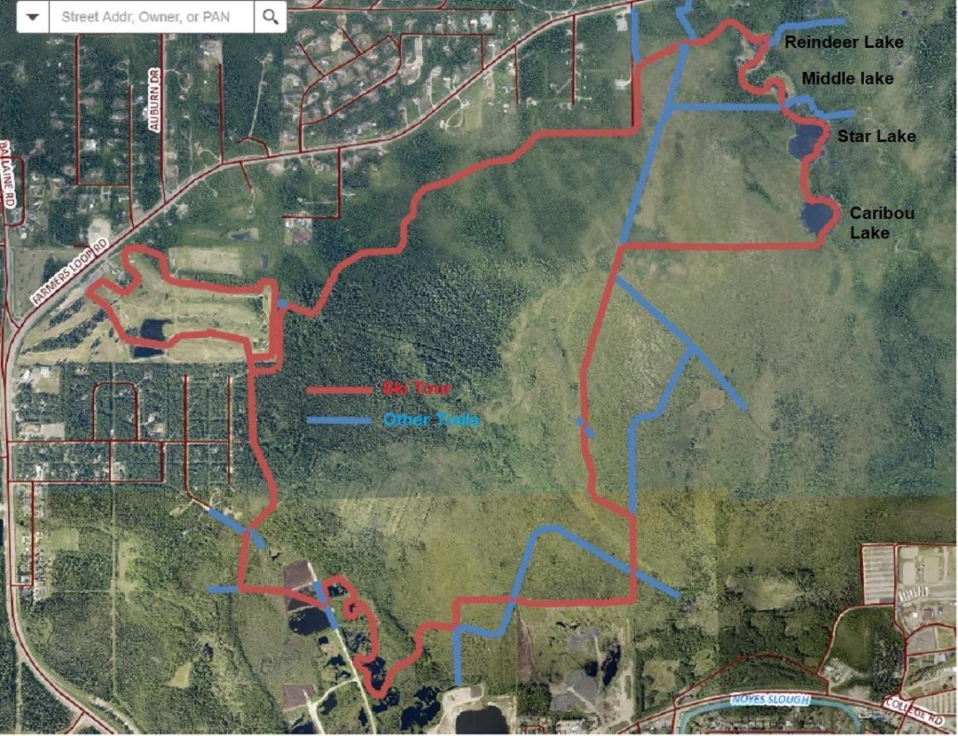 |
Tour starts at the Golf Course parking lot near the intersection of Ballaine and Farmers Loop Roads. Alternatively, start at the 7th-Day Adventists’ church. It is mostly flat with a couple of sharp hills that can be walked. Most people classic ski but it has been double-poled. With luck there will be classic tracks – tracks sometimes get obliterated on the multi-use trails. Temperatures are similar to the airport.
There is also a Rat Ponds Lite tour. This tour starts at a small parking area where Midnight Sun Rd. meets Farmers Loop or the new IALT parking beside Farmers Loop across from Shuros Dr..
Muskrat Ponds, officially known as Caribou Lakes, is a charming series of ponds reminiscent of the “Beaded Streams” one sees on the North Slope. The ponds are melting the surrounding permafrost, causing trees to lean towards the lakes or be submerged. Some ponds are filling in and being overgrown with cattails. They are shallow so as they cool in the fall. Benard cells form with “warm” water rising in the center of the cell and cool water sinking at the edges. As ice forms, the center of the cell remains ice free thus the eyes we see in this and other shallow lakes. When snow falls. its weight pushes the ice down and water exits from the eyes forming dendritic patterns in the snow around the eye. In some years we have seen muskrat “push ups” – mounds of plant material the muskrats build for protection.
Old Growth Forest – A term normally applied to places with giant trees, Mark Ross of Fish and Game applies it to black spruce bog country. We ski through long sections where no tree is taller than 20 feet but all are very old.
Leaning Towers – In the early days of radio, long wires were strung from poles to try and communicate with far flung parts of Alaska and the world. They were in the shape of a rhombus thus were called rhombic antennas. We pass by two of the abandoned poles leaning at crazy angles. In 2002 the largest of the poles broke and crashed to the ground.
Long Antenna – There is a long straight line running SSW to NNE all the way across the flats. It was a long antenna from the College Road Receiving Station. This was in the early days of wireless communication and the receiving station was run by the military. The line was pointed at Hawaii. There was also a second long antenna that pointed towards the Lower 48.
Creamers Refuge – the ponds are within the Creamer’s Refuge Boundary. The management plan mentioned a parking area where Midnight Sun Road meets Farmers Loop. In 2023 the interior Alaska Land Trust opened a new parking area just east of the one at Midnight Sun Rd.
Peat Ponds – Eventually we leave the natural forest and drop down onto excavations where Great Northwest excavated peat from UAF lands leaving many shallow ponds. Moose love this area for all the new growth.
Army Installation – Army Road once led to an Army infrasound installation for monitoring nuclear testing.
Mushing Trails – As much as possible the tour is routed off of the Mushing Trails but in some areas, there are no alternatives. We are on sections of what is known as the 19.8 Mile Trail. The trail that crosses the lakes is the 27.2 Mile Extension. You can find maps of the ADMA trails at http://alaskadogmushers.com/
Methane – There are areas with high methane emissions from decaying vegetation. When the ice is thin it is a good place to drill holes to allow the methane to escape and ignite it. There are areas where you can smell the methane.
Additions to Creamers – In 2020, 530 acres of UA land was purchased by The Conservation Fund and transferred to Creamers Refuge. Two private parcels were also added, the 50 acres that Henrik Wessel owned and 40 acres owned by the Nava family. Next in line for addition to the Refuge are trail rich lands just N of the Fairgrounds (completed in 2023). Much of the funding came from the Pitman Roberts Fund plus generous donations from private individuals.